Sunday, February 20, 2011

Iceland weather 2010 and consequences of the Eruption.

 
Distribution of ash thickness, Eyjafjallajökull eruption  Discharge from Jökulsá á Fjöllum, during 5 summers
source: Iceland Met Office 

ENG: I now have some answer to my questions. The Iceland Met Office published 2 very interesting reports: one about the fairly warm year of 2010 in Iceland and one about the consequences of the ashes of the Eyjafjallajökull eruption. It's very interesting and you can see that I experienced big above average river floods all around the Vatnajökull. This shows my not so idiot reaction of walking onto 2 glaciers without crampons! The water discharge of the Jökulsá á Fjöllum is roughly 40% higher in July 2010 (black) compared to the previous 4 summers. And obviously was the trend for all other rivers.

FRA: à traduire.

NL: te vertalen

Icelandic weather and windchill

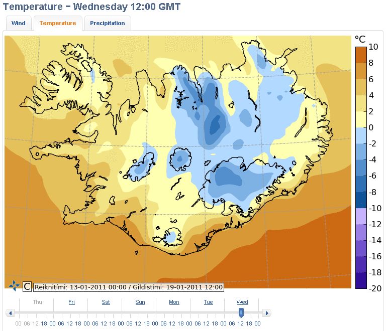
ENG: Below, what can be experienced in quiet good weather for mid-January.
FRA: Ci-dessous, de bonnes conditions météo en Islande pour la mi-Janvier.
NL: Hieronder, goeie weersomstandigheden in Ijsland voor midden Januari.
source : Icelandic Met Office


Weather - Météo - Weer (temperature,  wind, precipitation)
  
Monday-Lundi-Maandag 17/01/2011 @ midnight-minuit-middernacht.
  
Tuesday-Mardi-Dinsdag 18/01/2011 @ midnight-minuit-middernacht.
  
Wednesday-Mercredi-Woensdag 19/01/2011 @ noon-midi-middag.

Windchill - Sensation de froid - Gevoelstemperatuur.

Saturday, February 19, 2011

Iceland Winter Map

ENG: This satellite photo has been taken on the 18th of February 2011 by ENVISAT , which is the largest Earth Observation spacecraft ever built and launched in 2002. I've been using several times satellite imagery, the last times was to monitor the flood of Lake Eyre in Australia in 2007 & 2008 to prepare for the Simpson desert crossing. It seems this year the snow cover isn't too bad. For next year I hope there's gonna be enough snow but not too much.

FRA: Cette photo satellite a été prise par ENVISAT le 18/02/2011. Celui-ci fût lancé en 2002 et est le plus gros engin d'observation terrestre jamais construit.. J'avais déjà eu recours à ces photos en 2007-2008 pour vérifier le remplissage du lac Eyre en Australie pour préparer la traversée du désert de Simpson. On dirait qu'il y a un beau manteau neigeux. J'espère en avoir un l'année prochaine qui sera pas trop fin et pas trop épais.

NL:

Wednesday, October 13, 2010

my Inspired by Iceland video

ENG: Just watch and I hope you enjoy my video to promote Iceland. Please share if you like.
FRA: Regardez et j'espère vous faire rire. Merci de partager cette vidéo si vous aimez.
NL: Vindt u deze video leuk, deel het met jouw vrienden.

Tuesday, August 31, 2010

Summer Iceland Path Debrief


ENG: I have finished linking all 700 GPS points together. The result is shown in GoogleEarth including the elevation profile.

Distance linked points: 430km (370km between 2 extreme latitudes)
Estimated distance walked 600km.
Echography and X-rays of my leg didn't show fractures 4 weeks after finishing.

Summer Route in G-Maps or Download for G-Earth  

FRA: J'ai terminé de relier les 700 points GPS. Voici le résultant avec élévation dans GoogleEarth. La distance entre tous les points reliés est de 430km (370km en ligne droite entre le point de départ et d'arrivée) La distance de progression effective est estimée à 600km.
L'échographie et les rayons-X de ma jambe ne montrent pas de fractures après 4 semaines depuis la fin de l'expédition.

NL: Ik ben klaar met het verbinden van de 700 GPS punten. U ziet de hoogte profiel van de route en alle punten verbonden maakt een afstand van 430km. (370km in rechte lijn tussen het begen en einde punt) Ik veronderstel dat ik ongeveer 600km aflegde. De echografie en röntgenstralen tonen geen breuken aan m'n been vier weken na het einde van de expeditie. 

Sunday, August 1, 2010

In Reykyavik

ENG: It's LouPhi. I hitchhiked today to Reykyavik after waiting 1h30 on the ring road. I am staying at the salvation army (where I met a Belgian friend of Pierre Soete, see last years' Everest expedition). I will put photos ad add text to the previous posts early August, stay tuned. I am very skinny but will fid a scale to know how much I've lost. I will also upload the entire GPS route (700 points or so) on my main website for download. Arriving in the capital, I was already in the news (online) as someone would have followed the blog. Tomorrow I will go to RUV TV studio for giving video and interview. I expect to meet Halldor Kvaran and the pulkahut then take the plane and arrive in Paris at 6.30 am on Monday and at work at 10 in Brussels. Thanks for all comments, I will reply later.
I ate almost nothing yesterday night (100gr of chocolate left) but today my breakfast at 1pm consisted of 5 snickers + 1 foot long subway + 6inch inch subway sandwich.

I have a lot of surprises and stunning HD video and photos. Winter possible ? maybe, I'll have to try but with equipment and sponsors. No more glaciers without crampons, promised !

FRA:

NL: